New Report: American Sāmoa Faces Health Threats, Stronger Storms, and Challenges for Coral Reefs from Climate Change
HONOLULU (June 8, 2021) – Human health risks, stronger cyclones, coral reef death, and coastal flooding are among the major challenges detailed in a new report on climate change in American Sāmoa. Threatened resources include high-value coastal infrastructure and the millions of dollars that ocean ecosystems add to American Sāmoa’s economy annually, according to the report by the Pacific Islands Regional Climate Assessment (PIRCA), a consortium of several government, NGO, and research entities.
 Climate Change in the American Sāmoa: Indicators and Considerations for Key Sectors is one in a series of new PIRCA reports. Authors from American Sāmoa Community College, the University of Hawaiʻi, and the East-West Center—along with more than 20 technical contributors from local government, NGOs, and research—collaboratively developed the American Sāmoa PIRCA report.
“Places like American Sāmoa are always likely to be among the very first to see environmental impacts. The ocean is a major part of most aspects of Samoan life, and fishing is our chief industry,” said Congresswoman Uifa‘atali Amata, American Sāmoa’s representative in Congress. “A thorough climate report that is specific to American Sāmoa will be an excellent lasting resource. I appreciate all the work that went into this process, as we work to safeguard our beautiful islands, especially issues like promoting reef health, preventing severe wave damage, and preserving shorelines from erosion.”
Key Messages
Climate Change in American Sāmoa lays out the changes the Territory is already experiencing, as well as what lies ahead. The key messages for decision-makers include:
- Temperatures have risen, and hotter days and nights affect human health. Heat waves can exacerbate a range of pre-existing health issues, and hot weather poses a particular threat to children and elderly people.
- Stronger tropical storms and cyclones are expected globally and around American Sāmoa. More intense tropical cyclones mean a greater potential for loss of life, damage, and public health issues from these storms.
- Sea level rise threatens infrastructure, including drinking water, agriculture, housing, and transportation, as well as ecosystems and cultural sites. More frequent and intense coastal flooding and erosion are anticipated as sea level rise accelerates. Continued effects of the 2009 earthquakes magnify local sea level rise in American Sāmoa.
- Oceans are
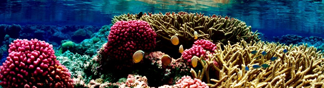
 warming, causing coral bleaching that is already widespread and severe. Extensive coral loss is possible within the next few decades if current trends in rising ocean temperatures continue. American Sāmoa has some of the oldest and largest corals in the world, and coral reefs inject millions of dollars annually into the local economy. In addition, American Sāmoa’s fringing coral reefs provide the best natural shoreline protection for the island.
Photo: Coral bleaching off Tāfuna, American Sāmoa. Credit: Valentine Vaeoso.
About Climate Change in American Sāmoa and the PIRCA
The collective efforts of the technical contributors, coordinating authors, and PIRCA Advisory Committee made the American Sāmoa PIRCA report possible. The report builds upon the US Fourth National Climate Assessment, offering a closer look at climate change impacts in American Sāmoa and providing information for a wide range of sectors.
The PIRCA is funded and supported by the US National Oceanic and Atmospheric Administration’s RISA Program (through the Pacific RISA), the East-West Center’s Research Program, the Pacific Islands Climate Adaptation Science Center, and the US Global Change Research Program.
Contact American Sāmoa PIRCA authors:
Kelley Anderson Tagarino, University of Hawaiʻi Sea Grant College Program, American Sāmoa Community College, Mapusaga, +1-684-699-3353
Victoria Keener, East-West Center, Honolulu, HI, +1-808-944-7220
Zena Grecni, East-West Center, Honolulu, HI, +1-808-944-7242
Christopher Shuler, University of Hawaiʻi Water Resources Research Center, Honolulu, HI, +1-808-956-7847
Wendy Miles, US Fish and Wildlife Service and East-West Center, Honolulu, HI, +1-808-284-7636
Protecting Native Forests Saves Water for People and Ecosystems
Leave a Comment
Posted on August 10, 2021 by pacrisa
Almost 99% of Hawaiʻi’s drinking water comes from water stored underground in aquifers across the islands, and groundwater supplies are impacted by changes in both land cover and climate. The NSF funded ‘Ike Wai (knowledge of water) Project at the University of Hawaiʻi spans multiple scientific disciplines and connects researchers to better understand how future land use and climate change might change groundwater recharge, and how, this in turn would influence water management decisions.. Following the stakeholder-driven approach used in the Pacific RISA Maui Groundwater Project, we worked with the State Department of Forestry and Wildlife, the Koʻolau Watershed Partnership, the City and County of Honolulu, and the State of Hawaiʻi Department of Planning to come up with a set of possible futures of conservation, urban, and agricultural land in the most heavily utilized aquifer on Oahu: the Pearl Harbor aquifer. Pacific RISA co-lead Laura Brewington developed the future land cover scenario maps as inputs to the groundwater model, which was run by the US Geological Survey. The scenarios reflected both transit-oriented development (dense development around the projected corridor for the Honolulu light rail project) and sprawl-type development (a business-as-usual approach), in combination with varying degrees of agricultural intensification or reduction and native forest protections.
Sustainable yield estimates and resulting differences in replacement costs were estimated for the six land cover scenarios crossed with two water demand scenarios under a potentially drier future climate. The results showed that both climate and land cover change were important drivers of changes in groundwater recharge. The degree of watershed protection, through preventing the spread of high-water-use, invasive plant species, had a much stronger impact than urban development. Specifically, protecting all of the aquifer’s native forests increased sustainable yields by 7–11% (30–45 million liters per day) and substantially decreased treatment costs compared with no forest protection. Furthermore, the greatest benefits to recharge occurred in the upper elevations of the watershed, which impacted the Waipahu-Waiawa and Waimalu subaquifers most substantially.
Read More
Explore the 2021 PIRCA Report for American Sāmoa
Leave a Comment
Posted on June 10, 2021 by pacrisa
New Report: American Sāmoa Faces Health Threats, Stronger Storms, and Challenges for Coral Reefs from Climate Change
HONOLULU (June 8, 2021) – Human health risks, stronger cyclones, coral reef death, and coastal flooding are among the major challenges detailed in a new report on climate change in American Sāmoa. Threatened resources include high-value coastal infrastructure and the millions of dollars that ocean ecosystems add to American Sāmoa’s economy annually, according to the report by the Pacific Islands Regional Climate Assessment (PIRCA), a consortium of several government, NGO, and research entities.
“Places like American Sāmoa are always likely to be among the very first to see environmental impacts. The ocean is a major part of most aspects of Samoan life, and fishing is our chief industry,” said Congresswoman Uifa‘atali Amata, American Sāmoa’s representative in Congress. “A thorough climate report that is specific to American Sāmoa will be an excellent lasting resource. I appreciate all the work that went into this process, as we work to safeguard our beautiful islands, especially issues like promoting reef health, preventing severe wave damage, and preserving shorelines from erosion.”
Key Messages
Climate Change in American Sāmoa lays out the changes the Territory is already experiencing, as well as what lies ahead. The key messages for decision-makers include:
Photo: Coral bleaching off Tāfuna, American Sāmoa. Credit: Valentine Vaeoso.
About Climate Change in American Sāmoa and the PIRCA
The collective efforts of the technical contributors, coordinating authors, and PIRCA Advisory Committee made the American Sāmoa PIRCA report possible. The report builds upon the US Fourth National Climate Assessment, offering a closer look at climate change impacts in American Sāmoa and providing information for a wide range of sectors.
The PIRCA is funded and supported by the US National Oceanic and Atmospheric Administration’s RISA Program (through the Pacific RISA), the East-West Center’s Research Program, the Pacific Islands Climate Adaptation Science Center, and the US Global Change Research Program.
Contact American Sāmoa PIRCA authors:
Kelley Anderson Tagarino, University of Hawaiʻi Sea Grant College Program, American Sāmoa Community College, Mapusaga, +1-684-699-3353
Victoria Keener, East-West Center, Honolulu, HI, +1-808-944-7220
Zena Grecni, East-West Center, Honolulu, HI, +1-808-944-7242
Christopher Shuler, University of Hawaiʻi Water Resources Research Center, Honolulu, HI, +1-808-956-7847
Wendy Miles, US Fish and Wildlife Service and East-West Center, Honolulu, HI, +1-808-284-7636
New Resource: SPREP’s State of the Environment and Conservation Report for the Pacific Islands
Leave a Comment
Posted on May 5, 2021 by pacrisa
Last week the Secretariat of the Pacific Environment Programme (SPREP) went live with their new website and resources pages to accompany the 2020 State of Environment and Conservation Report for the Pacific Islands, which was featured at the 10th Annual Pacific Islands Conference for Nature Conservation held virtually from Noumea.
This report is the first of its kind with coverage for the entire Pacific region, and it uses regional environment indicators to assess the status, trends, and data quality and availability for the endorsed Pacific environmental priorities. It also includes an update of the State of Conservation in Oceania report produced in 2013, which was endorsed and published in 2017. Viewers can use the interactive report website to navigate through the thematic sections of the report, which include up-to-date snapshots on land and marine resources protection, biodiversity, climate change, and the built environment. Scorecards and trends evaluate and present the level to which the region was meeting, exceeding, or failing to meet the state of the environment indicators. Read More
Addressing Compound Threats through Pacific Regional Cooperation
Leave a Comment
Posted on April 5, 2021 by pacrisa
On March 25, the Pacific RISA was invited by the East-West Center and the Government of Japan to participate in a workshop on “Strengthening Resilience, Cooperation, and Partnership in the Pacific” in a panel focused on the impacts of compound threats such as climate and ecological change. Moderated by Dr. Victoria Keener, the panel featured Dr. Laura Brewington, Pacific RISA co-lead investigator, who said healthy ecosystems and natural resources can help insulate island communities from many of these threats, but they need protection and management. “Here in Hawai‘i and the Pacific, we’ve started to really focus on the interacting effects of climate change and biodiversity loss because our lives and livelihoods are so intertwined with our ecosystems,” she said.
The newly-formed Pacific Regional Invasive Species and Climate Change Management Network is among the regional, cooperative efforts underway to address the compound impacts of climate change and invasive species. Pacific RISCC gathers together scientists and natural resource managers to improve the ways that communities can anticipate and prepare for global warming and ecological change, said Brewington. Another regional initiative, the Pacific Invasives Partnership, has long worked on high-priority international invasive species issues, with members representing state and local institutions, non-governmental organizations and academia. The partners advocate for changes in the ways that governments approach compound threats and stressors to ecosystems, she said.
Read More
Our Vision
Pacific Island communities that are resilient to climate impacts and using climate information to manage risks.
Follow Pacific RISA
Archives